Trail  Le Pertuis - Malrevers retournac - Photo
© OpenStreetMap contributors
Length
Length
82 km
Max alt
Max alt
1217 m
Uphill gradient
Uphill gradient
2667 m
Km-Effort
Km-Effort  
119 km
Min alt
Min alt
503 m
Downhill gradient
Downhill gradient
2893 m
Boucle
Boucle
No
Creation date :
2024-02-18 09:27:33.0
Updated on :
2024-08-24 06:15:34.318

(1 Reviews)


Scan this QR Code to open this trail in the SityTrail application

FREE GPS app for hiking

Logo SityTrail SityTrail

IGN / Geographical institutes

Download SityTrail from the App Store Download SityTrail from Google Play

Logo SityTrail SityTrail World

The world is yours!

Download SityTrail from the App Store Download SityTrail from Google Play Download SityTrail on Huawei AppGallery

About

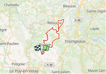
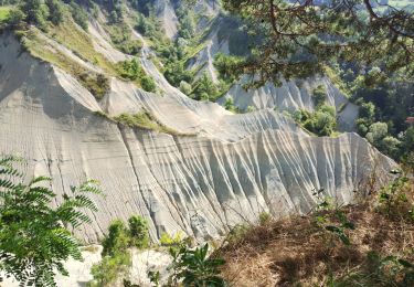
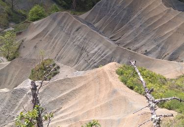
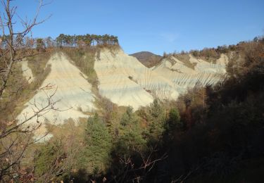
Trail of 82 km to be discovered at Auvergne-Rhône-Alpes, Haute-Loire, Le Pertuis. This trail is proposed by Vodkakoka.

Description

En quad.
Chemin des 13 rivières, bois de vaux, blanhac

Elevation profile

Positioning

Country:
France
Region :
Auvergne-Rhône-Alpes
Department/Province :
Haute-Loire
Municipality :
Le Pertuis
Location:
Unknown
Start:(UTM)
582912 ; 4994149 (31T) N.

Comments

Please log in to post a review or rate the element


Trails nearby

Trail Walking Rosières - 20201005 ravin de Corboeuf - Photo
Walking
ThonyM

Walking

Easy
(1)
Rosières, Auvergne-Rhône-Alpes, Haute-Loire, France
3.7 km | 5.4 km-effort
52min
Yes
Trail Walking Rosières - 2020-02-21 13:18:03 Chronomètre - Photo
Walking
GilGry

Walking

Very difficult
Rosières, Auvergne-Rhône-Alpes, Haute-Loire, France
16.8 km | 26 km-effort
5h 25min
Yes
Trail Walking Rosières - Rosières 43 - Photo
Walking
belleney

Walking

Very easy
Rosières, Auvergne-Rhône-Alpes, Haute-Loire, France
10.7 km | 13.7 km-effort
2h 56min
Yes
Trail Walking Saint-Étienne-Lardeyrol - La Huche Plate - Lachaud de Rougeac - Photo
Walking
tracegps

Walking

Medium
Saint-Étienne-Lardeyrol, Auvergne-Rhône-Alpes, Haute-Loire, France
8.9 km | 12.2 km-effort
2h 30min
Yes
Trail Mountain bike Rosières - La Suissesse en Galoche - Rosières - Photo
Mountain bike
tracegps

Mountain bike

Medium
Rosières, Auvergne-Rhône-Alpes, Haute-Loire, France
17 km | 22 km-effort
2h 30min
Yes
Trail Walking Rosières - La Suissesse en Galoche - Rosières - Photo
Walking
tracegps

Walking

Difficult
Rosières, Auvergne-Rhône-Alpes, Haute-Loire, France
17 km | 22 km-effort
4h 30min
Yes
Trail Walking Rosières - Ravin de corbeuf  - Photo
Walking
cousam

Walking

Easy
Rosières, Auvergne-Rhône-Alpes, Haute-Loire, France
3.7 km | 5.4 km-effort
1h 6min
Yes
Trail Walking Rosières - Ravin de Corboeuf - Photo
Walking
Jackoyo

Walking

Very easy
Rosières, Auvergne-Rhône-Alpes, Haute-Loire, France
3.9 km | 5.6 km-effort
1h 8min
Yes
Trail Walking Rosières - Rosières 43 - Photo
Walking
belleney

Walking

Very difficult
Rosières, Auvergne-Rhône-Alpes, Haute-Loire, France
16.8 km | 21 km-effort
4h 47min
Yes


Close
My subscriptions